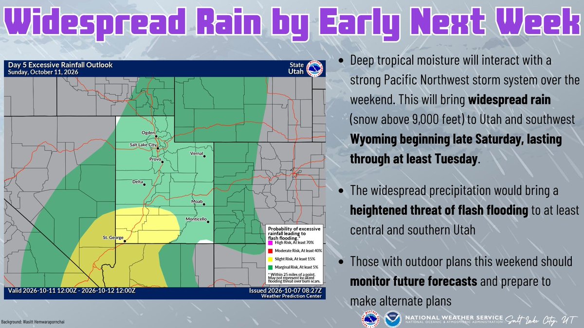
Heavy rain and a 20-degree temperature drop are forecast to hit Alpine, Highland, Cedar Hills and Lehi starting Saturday, Oct. 10, as remnants of Hurricane Rachel merge with a cold Pacific Northwest storm system.
The National Weather Service Salt Lake City said on X on Wednesday, Oct. 7, that tropical moisture will interact with the strong system to bring widespread rain to Utah from late Saturday through at least Tuesday. Snow is expected above 9,000 feet.
The agency identified a heightened flash flood threat for central and southern Utah. Hayden Mahan, a meteorologist with the NWS in Salt Lake City, told KSL on Thursday, Oct. 8, that the service was meeting with partner agencies to decide whether to issue a flood watch. He identified Sunday, Oct. 11, and Monday, Oct. 12, as the days with the strongest flooding potential.
Mahan said the flash flood risk from this storm extends beyond the usual trouble spots of slot canyons, dry washes and burn scars. Urban areas with poor drainage and main-stem rivers are also at risk, he said.
"We're going to have to keep an eye on places like urban areas and even main stem rivers that could see a lot of water and potentially flash flooding issues," Mahan told KSL.
The storm's path still carries uncertainty. ABC4 Utah reported Thursday, Oct. 8, that the National Hurricane Center forecast shows Rachel making a sharp turn west through the Southern California coastline as a tropical storm, then moving into southwest Utah by Sunday night as a tropical depression. Mahan told St. George Utah News that some models keep the track farther west while others push it east.
KSL Weather models project many mountain areas could receive 3 inches of precipitation or more by Wednesday night, Oct. 14. Communities across northern Utah, including the Salt Lake City area, could see 1.5 to 2 inches or more over that period.
Temperatures in the Alpine-Lehi corridor were running in the low to mid-80s on Thursday, Oct. 8, about 10 to 15 degrees above average, according to ABC4. Highs are expected to fall to the 60s in northern Utah by early next week as the storm moves through.
The rain arrives as more than 75% of Utah remains in severe or extreme drought, according to KSL. The NWS confirmed extreme drought conditions persist across much of the state in its latest monthly Drought Impact Statement, released Tuesday, Oct. 6. Mahan said the moisture could help improve soil moisture levels and spring snowpack runoff, though flooding remains the immediate concern.
The unsettled weather is expected to last through about Wednesday, Oct. 14, driven by Rachel's moisture and a slow-moving cutoff low-pressure system, Mahan told St. George Utah News.
No formal flood watch had been issued for Utah County as of Thursday, Oct. 8. In an advisory posted Tuesday, Oct. 6, the NWS urged anyone with outdoor plans to monitor forecasts and make backup plans. Residents can check weather.gov/slc or follow @NWSSaltLakeCity on X for updates.

.png)



.webp)
